Filling a void
In the increasingly populated scene of London mapping there was still something very basic missing.
London boroughs constitutes an important part of the administration of the city: they are responsible for many local services: school, social services (including housing), waste management, parks, and have a say also in the public transport. To fund them, resident pay a council tax which varies a lot between boroughs. Also, the elections for the borough council are the only one where non-citizen can vote, given their local scope.
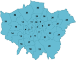
One problem is that as of yesterday I had no idea how most boroughs were placed around London. Yes, you can easily find maps like the one on the right on Wikipedia, but it is hardly informative: it is definitely too hard to navigate it without any landmark. An image search for london borough map also gives almost always highly stylized maps that do not show much more than just the boroughs’ boundaries.
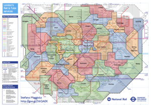
And honestly, there are not a lot of landmarks I would recognize outside of zone 2… wait, there are some: the tube stations! I rarely go outside zone 2 even with the tube, but I got used anyway to most names just by looking at the line maps while traveling. And this must be true for many people, because when I type “london borough map” on Google, on of the first completions it suggests is “with tube stations”. Sadly, I could not find any map with this information, so I created it! You can see it on the left as a png (click to enlarge and download), or get the pdf file. The main source is of course Tfl’s wonderful tube and rail map, and just a couple of hours of Inkscape did the trick.

